RTI's Nature-Based Solutions (NBS) Explorer Tool


In the face of complex environmental challenges, innovative solutions are pivotal for safeguarding our communities and natural resources. The NBS Explorer, developed by RTI International, offers a transformative, hands-on approach to addressing pressing issues such as flooding and water quality decline. This web-based tool empowers stakeholders to evaluate and implement nature-based solutions (NBS) that not only mitigate current and projected risks, but also enhance the resilience of local ecosystems.
The NBS Explorer is a user-friendly tool built on RTI’s Watershed Flow and Allocation (WaterFALL®) model platform. The NBS Explorer helps groups and individuals, like conservation organizations, land managers and water resources planners, evaluate the use of nature-based solutions in their communities and watersheds. By combining physical data, modeling, and insights on the community’s interest in nature-based solutions implementation, the NBS Explorer guides users through the selection of suitable project locations, feasible nature-based solutions types, and typical design parameters. This makes it easier to estimate the benefits of different interventions, such as wetland restoration and green infrastructure integration.
Since the WaterFALL model simulates the hydrologic and water quality dynamics at the land use scale, NBS Explorer evaluations provide both local hydrologic and water quality benefits and the cumulative benefits downstream of one or more nature-based solutions practices. Additionally, the NBS Explorer guides users in their selection of nature-based solutions through Opportunity Map layers, which identify areas that are both physically suitable for the implementation and likely to provide benefits to human and ecological communities.
One of the core strengths of the NBS Explorer is its user-friendly interface that allows users to navigate the mapping interface and visualize potential project impacts, regardless of technical expertise. The point-and-click, map-based application provides users with all the information needed to examine a range of nature-based solutions implementations. It automatically defines a watershed for their area of interest and presents pre-populated data, informed by local design criteria and limited by watershed characteristics, as users step through the NBS parameter setup. For example, users can only implement agricultural conservation practices on existing agricultural lands and the NBS practice size and capture area will be limited to the area of that land. Similarly, the infiltration rates of the runoff captured by the practice will be guided by the underlying soil conditions for the area.
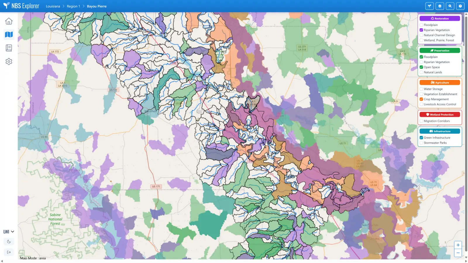
In the map view of NBS Explorer, users can choose different basins to select a subwatershed of interest as shown here. Each subwatershed is defined by a set of hydrologically linked catchments. Users can turn on and off the Opportunity Map layers showing catchments identified to be high priority candidates for each NBS type and practice.
By automating the gathering of spatial and temporal data and minimizing the elements requiring technical decisions for NBS practice implementation, users without extensive technical knowledge can run a model and view results. This levels the playing field for all users of the NBS Explorer—whether they are community members seeking to resolve local flooding issues, scientific or conservation community members focused on watershed-wide issues, or commercial entities aiming to protect their water supply or give back through water stewardship actions.
When implementing nature-based solutions it is crucial to have a clear understanding of their ability to reduce the hydrologic or water quality issues in question—not only for measuring the benefits, but also for being able to speak to these benefits prior to implementation to facilitate funding applications and ensure public support. The NBS Explorer quantifies the NBS benefits by specifying changes within the hydrologic regime (e.g., runoff, baseflow, etc.) and within the processes of water quality load generation and transport, both locally and downstream, using WaterFALL model simulations.
For example, the NBS Explorer may highlight that an NBS practice reduces local runoff by two inches per year, which decreases peak flow events in the local and downstream stream reaches. In terms of water quality benefits, model evaluations may show a 40% reduction in sediment loading from the land surface in the catchment where the NBS is implemented and a 25% reduction in the sediment load transported to the outlet of the watershed of interest.
The ability to quantify multiple primary and secondary (or co-) benefits is especially valuable, enabling stakeholders from any background to engage in informed collaborative decision-making that aligns with their unique needs and conditions. RTI’s work with the Catawba-Wateree Water Management Group (CWWMG) in North and South Carolina exemplifies this collaborative approach. The CWWMG Source Water Protection Committee, composed of members from water and energy utilities, the commercial sector, conservation organizations, and technical experts, uses the principles underlying the NBS Explorer to advance source water protection projects such as stream restoration and land conservation. These projects are proposed based on varying benefit objectives and funding needs. Through this effort, stakeholder needs are met; conservation groups obtain quantified water quality load reductions for funding applications; corporate members receive values reportable as part of Volumetric Water Benefits Accounting with additional data for Water Quality Benefit Accounting; and CWWMG utility members ensure their funding supports projects with significant flow and load reductions, maintaining their high-quality and secure water supply.
In smaller communities lacking technical expertise and/or funding, the NBS Explorer is a cost-effective tool for evaluating different mitigation needs, as demonstrated by the Village of Natchez in rural Louisiana. Here, a set of green infrastructure practices were identified, located, and sized to provide flood mitigation through the Main Street corridor. Using the NBS Explorer results, Natchitoches Parish was awarded state-level funding to pursue full design and implementation of the flood mitigation project for the village.
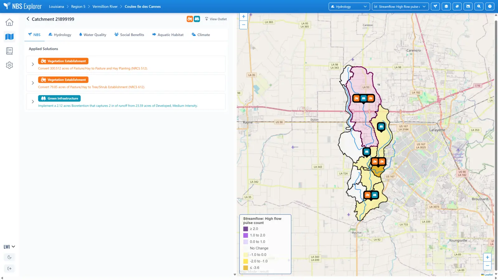
In this example project, several types of agricultural conservation practices and green infrastructure were implemented in a small, urbanizing subwatershed. Users can view the project inputs and tabular results on the left-hand side of the screen and the mapped, metric-based results on the right side of the screen. The pink highlighted catchment in the map identifies which inputs and results are shown in the left-hand view. There are tabs to review the NBS practices implemented (shown) and then the Hydrology, Water Quality, Social, and Aquatic Habitat benefits due to NBS implementation. The user can click on the map to select different catchments to review results.
The Louisiana Watershed Initiative (LWI), within Louisiana’s Office of Community Development, works to reform the state’s approach to flood mitigation by coordinating funding, data, and resources among five state agencies using a watershed-based approach. LWI’s holistic method of watershed management goes beyond conventional mitigation measures and incorporates nature-based solutions.
As part of LWI’s pursuit to quantify and mitigate inland flooding, it contracted with the Louisiana Chapter of The Nature Conservancy (TNC) and RTI to develop WaterFALL models and set up an NBS Explorer application. This LWI-supported application enables public examination of NBS projects to increase flood resilience and establish co-benefits. LWI’s regional watershed coordinators, responsible for developing watershed plans, will begin testing the Louisiana NBS Explorer deployment to explore NBS projects proposed for their communities later this month, with full end-user training for interested stakeholders conducted by TNC early in 2026. The work for LWI was recently described during a 2025 World Water Week online session, which can be viewed in full here.
As part of its broader mission, RTI is dedicated to equipping communities with the training and resources necessary for successfully leveraging the NBS Explorer. With initiatives focused on prioritizing NBS projects, supporting communities, and quantifying and valuing environmental benefits, RTI aims to build capacity for and foster collaboration among stakeholders from all sectors. This commitment ensures that the benefits of NBS reach the communities that need them most while promoting water stewardship efforts through all available channels.
Opportunities to learn more about the NBS Explore:
The NBS Explorer marks a significant step forward in integrating science and community engagement in environmental planning. By quantifying the power of nature, this innovative tool not only addresses immediate challenges like flooding, but also contributes to broader goals of environmental resilience and ecological health. As the NBS Explorer is deployed in more watersheds, we can look forward to a future where nature thrives and is valued, and communities and water users are better equipped to manage the environmental complexities arising from our changing climate and our continued use and development of natural resources.